Fig. 4
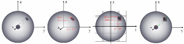
From left to right: 1) according to the stellar inclination and to the spot’s latitude and longitude, the xyz position of the nrho points on the spot’s circumference are calculated in 3-D. 2) The maximum and minimum y and z determine a smaller area where the spot is. 3) These {yz} positions (in 3D) are projected on the y-z plane, which gives (py, pz) positions. 4) From these values, a smaller grid is defined. Each cell of this grid is scanned. A reverse to that performed in step 1 rotation is performed to establish if the cell is inside the spot or not.

Current usage metrics show cumulative count of Article Views (full-text article views including HTML views, PDF and ePub downloads, according to the available data) and Abstracts Views on Vision4Press platform.
Data correspond to usage on the plateform after 2015. The current usage metrics is available 48-96 hours after online publication and is updated daily on week days.
Initial download of the metrics may take a while.